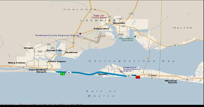
ROUND THE BAY RELAY AND ULTRA
  • Home
  • RACE UPDATES/BLOG
  • RESULTS
  • Register
  • Schedules/Start
  • Race Rules
  • ULTRA Runners
  • 5K Recovery Run
  • Photos
  • The Course
  • Hotel

The Course

  • NEW FOR 2025: The race will begin in front of The Island Hotel and runners will use the new BIKE PATH located on the south side (Gulf) of Highway 98. You will cross over to the north side after you run across the Destin Bridge.
  • BROOKS BRIDGE CONSTRUCTION- WILL BE UPDATED PRIOR TO 2025 RACE!!
  • * A map of the Brooks Bridge Construction area will be emailed to each team captain and ultra runners. The course change includes moving to the right side of Perry for the last block before Highway 98. We will cross 98 at the redlight (right side), turn left and run on the path beside highway 98 on the south/right side of the bridge. Once you leave the bridge, stay on the right side of 98 until the second red light at the Gulfarium. Using the light. cross 98 back to the north side (The Elks Lodge side) and finish at the Elks Lodge.

The 15th Annual Round the Bay Relay and Ultra originally had six legs covering the roads around scenic Choctawhatchee Bay in beautiful Northwest Florida. 
** You may still use those legs or choose your own based on the number of runners on your team. It helps when the relay team exchange zones are spread out around the course.

(Note: you can click maps to enlarge.)
Picture
RACE LEG #1:  THE ISLAND HOTEL TO FUD (Destin) (8.8 MILES)
HINTS: (Exchange zone is back to the original Relay stop at the entrance to Fudpuckers. 
  • Stay on the new Highway 98 BIKE LANE to the Destin Bridge.
  • Do not get vehicles off in the sand areas beside the road, especially on Okaloosa Island.
  • Mile 3.9- Destin Bridge- use sidewalks after crossing bridge
  • CAUTION: runners will use sidewalks through Destin, be careful crossing intersections.
  • Mile 4.7- McGuire’s parking lot
  • Mile 7.8- Continue on the sidewalk past The Track. Run straight to Fud's on 98. Support vehicles will pass Fud's and then turn left at the next light on Triumph Road. You can then turn left into the Fudpucker's/Fat Daddy's parking lot. 
  • Vehicles make sure you pull completely into all parking lots to eliminate congestion at exchange zones. Always look for runners and be careful when exiting parking lots.
Picture
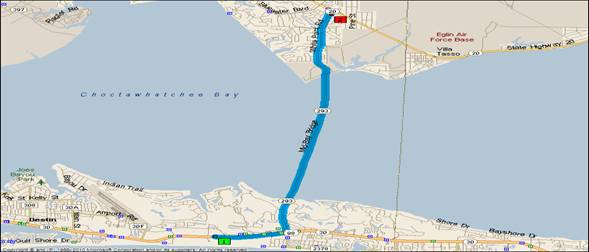
RACE LEG #2: Destin Fudpucker’s to Hurricane’s  (7.6 miles)
RACE HINTS: (Exchange zone in Hurricane’s parking lot)
  • Follow Highway 20 (sidewalk) to Matthew Blvd, which is between Wells Fargo Bank and Starbucks. Turn left on Matthew Blvd, stay on the right side of the round-about and run through the parking lot to Bonefish Grill. Once you get through the parking lot, turn left on sidewalk beside Danny Wuerffel Way at Bonefish Grill and follow Highway 293  to the Mid-Bay Bridge.
  • CAUTION: Narrow bridge entry creates pinch point. Use extreme caution.
  • Bridge Toll Booth- vehicles must pay toll, runners are free. 
  • Vehicles: after passing through Toll Booth, go .1 miles take exit to the right, turn left at stop sign (.4 after toll booth) drive under the overpass to White Point Road (0.9 from toll booth). Turn left on White Point Road and go to cul-de-sac for a water stop. This is a great place to meet your runner and to cheer other runners on.
  • Runners: after crossing bridge, take sidewalk that turns left to White Point Road. Your team should meet you there for water.
  • Run on sidewalk up White Point Rd. Vehicles drive up White Point Road.
  • Mile 7.5- Left turn into Hurricane’s. Exchange zone in parking lot.
Picture
RACE LEG #3 HURRICANE’S TO BAYOU PLAZA (6.6 miles)
  • The map to the left doesn't extend the blue line to Bayo Plaza!! You continue around the bend of the bayou and turn south on Government Ave/Highway 85 South.
  • Run sidewalk beside Highway 20.
  • CAUTION: No sidewalk from Lancaster Road to Rocky Bayou Bridge (miles 2.4-2.8); must use bike lane.
  • Pick up sidewalk after bridge for the rest of the leg.
  • Mile 4.9- Major intersection crossing Palm Ave.
  • Bayou Plaza (6.6 miles from the start) will be the exchange point. Vehicles should turn left into Bayou Plaza at the red light. 
Picture
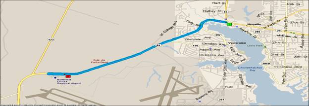
RELAY LEG # 4: BAYOU PLAZA TO NW FLORIDA REGIONAL AIRPORT (3.3 miles)  CARGO DELIVERY PARKING AREA                         

RACE HINTS: (Exchange zone is the north parking lot of the airport or under the overpass area.)
  •  Use red light to cross Highway 20. DO NOT CUT ACROSS HIGHWAY 230 prior to the redlight.
  • Use sidewalk on left side of road running up the hill on 85 South to FWB.
  • CAUTION: Mile 1.4, sidewalk runs out before bike lane begins.
  • Pickup bike lane at the Valparaiso Triangle-must cross exit road
AIRPORT INSTRUCTIONS:  
  • DO NOT GO INTO MAIN AIRPORT ENTRANCE AREA (RUNNERS or VEHICLES) AT ANY TIME
  • After runners make the exchange, the new runner will continue south on the service road.
  • As RUNNERS near the airport going south on 85, they will continue to run on the left side of the road, stay left onto airport service road. The exchange zone is at the entrance of the Cargo Delivery (north parking lot) area which will be on the runner’s left. DO NOT RUN ON THE OVERPASS!!
  • RACE SUPPORT VEHICLES must use off ramp to the right before the overpass. (signs to airport) After exiting on right side, turn left at the stop sign. After turning left, follow CARGO DELIVERY signs, which will be a quick left (20 yards) and a right (50 yards). Turn into Cargo Delivery (right before EXPLORE FLORIDA sign) area to park. Exchange zone is located at entrance to Cargo Delivery area.
  • To exit Cargo Delivery area, follow the signs for 85 South (Ft. Walton Beach) out of parking lot area. Once you get back to the stop sign at the service road, go straight across service road and go under the overpass. At stop sign, turn left going south. You are now on the service road. Go 100 yards, then turn left merging back on highway 85 South.  **Instead of entering the airport roads, you may also drive north on the service road and make a U-turn to head back south on 85.
Picture
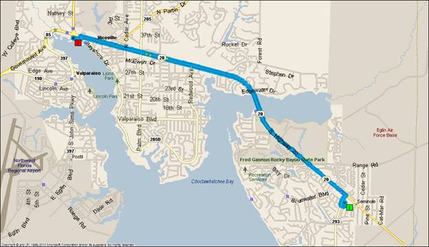
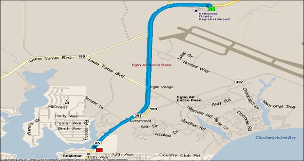
RELAY LEG #5: AIRPORT TO SHALIMAR ELEMENTARY SCHOOL (4.6 MILES)
RACE HINTS: (Exchange zone at entrance to school)
  • CAUTION: Mile 1.1- running south, must cross north bound exit ramp to Crestview
  • Mile 3.0- After Armament Museum,  run left side of overpass bridge. DO NOT CUT ACROSS HIGHWAY 85.
  • Mile 4.6- turn left into Shalimar Elementary School.
  • Vehicles: park in school drop-off lanes, move cars forward so others can enter, just like school!!!!!!
  • ​RUNNERS WILL NOT ENTER THE SCHOOL PARKING LOT BUT WILL REMAIN ON THE BIKE LANE OR THE SDIEWALK.
  • Exit with school signs to 12th Avenue. Right on 12th, then left at red light (100 yards) turning left/south on 85 South/Eglin Parkway. The same road the race leg followed.
Picture
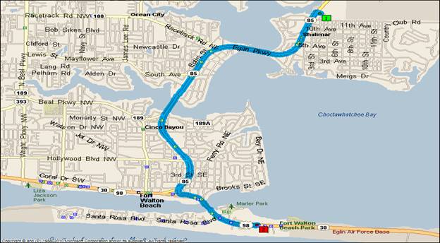
 RELAY LEG # 6: SHALIMAR ELEM. TO ELKS LODGE (5.8 MILES)
 
RACE HINTS: NEED EXPERIENCED RUNNER!!!
  • Vehicles, follow school road and turn right onto 12th Avenue, then turn left at red light onto 85 South.
  • CAUTION: Mile 1.1- Shalimar Bridge- must dodge fisherman and gear on bridge. There is a bike lane on inside of bridge, but very narrow.
  • Mile 2.4- can use parallel service road to bridge
  • Mile 2.8- Cinco Bayou Bridge. Watch for fisherman and gear.
  • Mile 3.5- Uptown Station- High traffic area.
  • CAUTION: Mile 4.2- turn left on Perry Ave. Must cross two oncoming streets
  • BROOKS BRIDGE CONSTRUCTION- AS WE GET CLOSER TO RACE TIME, MORE INFORMATION WILL BE GIVEN ABOUT THE ONGOING CONSTRUCTION ON BROOKS BRIDGE!!!!
  • Turn left on 98, cross Brooks Bridge, major intersection and then finish line at THE ELKS LODGE on the left at mile 5.8. There is bridge construction in this area.
  • Turn left into THE ELKS LODGE parking lot to finish. 
  • For safety reasons, the ELKS LODGE parking lot is a No Pass Area for runners. Please maintain your place and enjoy the finish joined by your team.
Proudly powered by Weebly
  • Home
  • RACE UPDATES/BLOG
  • RESULTS
  • Register
  • Schedules/Start
  • Race Rules
  • ULTRA Runners
  • 5K Recovery Run
  • Photos
  • The Course
  • Hotel